Santiam – Calapooia Regional Partnership
The North Santiam, South Santiam and Calapooia Watershed Councils’ mission is “Thinking and collaborating regionally to build capacity to work locally. Our Vision: Clean healthy waters with ecological flows, native species recovered and diverse, floodplain connectivity and healthy riparian forests, as well as stable economies with working landscapes that support local populations, and communities that sustain those natural resources. The vision’s foundation is sustained by educated youth and adults who behave as stewards of their watershed resources and prioritize investment into their local economies.”
Oregon Governor’s Fund Recipients, Calapooia-Santiam Partnership
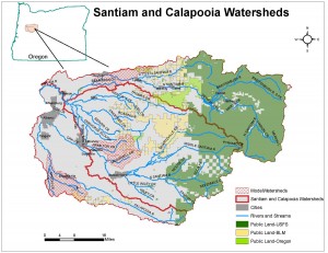
The North Santiam, South Santiam and Calapooia Watersheds have similar landscapes, starting in steep forested uplands and moving down to the Willamette Valley floor. Each has a mixture of land uses including forestry in the upper watersheds, which transitions to more agricultural type uses in the lower watersheds. Communities in each watershed are small to moderate in size and there are a growing number of small acreage landowners. The Santiam and Calapooia Watersheds historically supported Upper Willamette Chinook Salmon Evolutionary Significant Unit (ESU) and Steelhead Distinct Population Segment (DPS). The North and South Santiam represent two of the four core spring Chinook populations and all three watersheds represent three of the four historic winter Steelhead populations. All three watersheds are listed on the 303(d) list of water quality impaired water bodies primarily for exceeding summer water temperature standards. The Calapooia also has portions listed for E. Coli and the Santiam is listed for dissolved oxygen.
The three watersheds have similar restoration priorities that were reaffirmed by an online survey of 34 multi-disciplinary participants. Primary restoration priorities include aquatic/in-channel habitat, floodplain/riparian habitat and fish species recovery. Secondary restoration priorities include water quality and quantity, wetlands and upland habitat.
The following sub-basins or reaches were selected to plan, implement and monitor long-term restoration strategies to address the above priorities.
| North Santiam | South Santiam | Calapooia |
| Stout/Valentine Creek | McDowell Creek | Courtney Creek |
| Bear Branch | Hamilton Creek | Middle Reach |
Click Image for Larger View
The North Santiam, South Santiam and Calapooia watershed Councils have partnered with Meyer Memorial Trust and Bonneville Environmental Foundation to model a collaborative approach between regional watershed councils in developing and implementing an adaptive 10-year restoration and monitoring strategy. Please visit BEF’s Willamette Model Watershed Program website for more information. This collaboration shows ecological and economic efficiencies in working across traditional watershed boundaries and will be transferable to other Willamette Basin watershed groups interested in establishing similar efficiencies through collaboration. The Calapooia-Santiam Collaboration will focus on six sub-watersheds, each with a unique set of ecological, social and economic values, yet offering good points of comparison for study of watershed response to specific treatments. Restoration strategies will be developed for Courtney Creek and the middle reach in the Calapooia Watershed, McDowell and Hamilton Creeks in the South Santiam Watershed and Stout/Valentine Creeks and Bear Branch in the North Santiam Watershed. The lessons learned and tools developed in these sub-watersheds will be utilized in other sub-watersheds in the region as these groups leverage the Willamette Model Watershed Program funding outward to meet a broader restoration vision across the region.
Click to View Strategic Plan Summary: Summary-Calapooia-Santiam-Collaboration-for-Strategic-Watershed-Restoration


